The snow could be heavy at times.
WINTER STORM WARNING REMAINS IN EFFECT UNTIL 4 AM THURSDAY
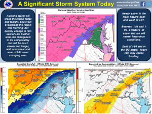
Baltimore, Md. – Heavy mixed precipitation expected through tomorrow. Total snow and sleet accumulations of 6-12 inches to the east of the Blue Ridge. Snow accumulations of 12-18 inches from the I-81 corridor westward, as well as near the Mason-Dixon Line. Ice accumulation of around a tenth of an inch near the Blue Ridge Mountains.
Affected areas include portions of north central and western Maryland, northern and northwest Virginia and eastern and panhandle West Virginia.
The warning remains in effect until 4 AM EST Thursday. Snow will mix with sleet and freezing rain during the afternoon and evening hours near the Blue Ridge mountains. The heaviest snow is most likely during the late afternoon and evening hours.
Travel could be very difficult to impossible. The hazardous conditions could impact the morning or evening commute. Visibility will be reduced below one-quarter mile at times in snow.